
Earthquake, earthquake, earthquake or earthquake among the people; It is a seismic fluctuation event that occurs as a result of unexpected energy release in the earth’s crust and shakes the earth. The earth’s crust is made up of spherical plate planks, and the movement of these plate planks can cause earthquakes to occur. A fault line is where one plate of plate moves, joins or separates with respect to another plate. These movements in the earth’s crust can cause stress to accumulate in an area of the earth’s crust, and stress accumulation can cause an earthquake to occur.
The occurrence of an earthquake occurs with seismic waves that emerge unexpectedly as a result of the accumulation of energy on fault lines in the earth’s crust. The magnitude of earthquakes is determined by the Moment Magnitude scale, and the intensity of the shaking is measured by the Mercalli intensity scale. Earthquakes can also be caused by the cracking of natural fault lines, by human factors such as volcanic activity, landslides, mine explosions or nuclear testing.

Active Fault Lines in Turkey
There are 3 major fault lines in total in Turkey; North Anatolian Fault Line, East Anatolian Fault Line and West Anatolian Fault Line. In the earthquake map, the colors of the provinces are used to indicate earthquake risks; The red colored provinces are defined as the first degree earthquake zone, the pink colored provinces as the second degree risk zone, the yellow colored provinces as the third degree seismic zone.
Where the Eastern Anatolian Fault Line passes through is included in the Turkey Earthquake Map prepared by AFAD. Turkey fault line map has been made available by AFAD to inform the public.
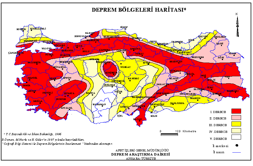
The East Anatolian Fault Line is a fault line in Turkey and can be seen on the Turkey Earthquake Map prepared by AFAD. The East Anatolian Fault Line is a fault line located in eastern Turkey. This line runs along the border between the Anatolian Plate and the Arabian Plate. The fault starts from the Maraş Triple Junction and moves in the northeast direction and meets the North Anatolian Fault Line at Karlıova Triple Junction.
Turkey Earthquake Hazard Map was renewed and published in the Official Gazette dated March 18, 2018, and entered into force on January 1, 2019. The project was supported within the scope of the National Earthquake Research Program (UDAP) carried out by the Presidency. In addition, support was provided by the Catastrophe Insurance Pool (DASK). In addition, “Turkey Building Earthquake Regulation” was published in the same dated RG and entered into force simultaneously.

First Degree Risk Areas
Izmir, Balikesir, Manisa, Mugla, Aydin, Denizli, Isparta, Usak, Bursa, Bilecik Yalova, Sakarya, Düzce, Kocaeli, Kirsehir, Bolu, Karabuk, Hatay, Bartin, Cankiri, Tokat, Amasya, Canakkale, Erzincan, Tunceli, Bingol and Muş, Hakkari, Osmaniye, Kırıkkale and Siirt
Second Degree Risk Areas
Tekirdağ, İstanbul (1st and 2nd Region), Bitlis, Kahramanmaraş, Van, Adıyaman, Şırnak, Zonguldak, Tekirdağ, Afyon, Samsun, Antalya, Erzurum, Kars, Ardahan, Batman, Iğdır, Elazığ, Diyarbakır, Adana, Eskişehir, Malatya, Kütahya, Çankırı, Uşak, Ağrı and Çorum
Third Degree Risky Areas
Eskisehir, Antalya, Tekirdag, Edirne, Sinop, Istanbul, Kastamonu, Ordu, Samsun, Giresun, Artvin, Sanliurfa, Mardin, Kilis, Adana, some regions of Gaziantep and Kahramanmaras, Sivas, Gumushane, Bayburt, Kayseri, Yozgat , Çorum, Ankara, Konya, Mersin and Nevşehir
Least Risk Areas
According to the Turkey Earthquake Map, the provinces in the fourth and fifth groups with the lowest earthquake risk are Sinop, Giresun, Trabzon, Rize, Artvin, Kırklareli, Ankara, Edirne, Adana, Nevşehir, Niğde, Aksaray, Konya and Karaman.


